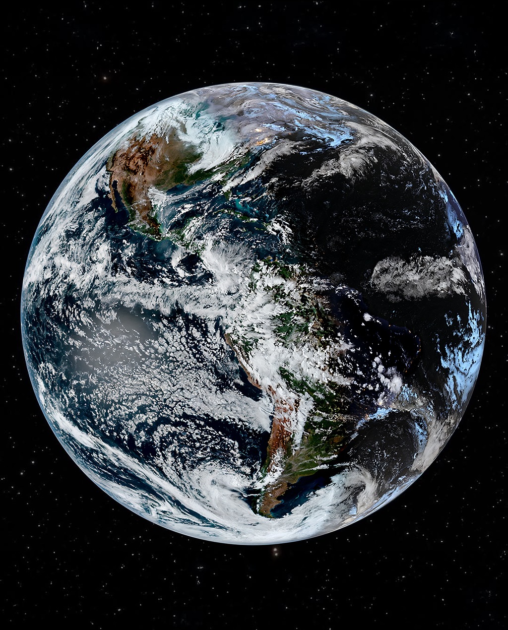
This Stunning Photograph of Earth Was Captured Just One Hour Ago by a NOAA Satellite — A Real-Time Glimpse of Our Planet from 35,786 Kilometers Above
At precisely 3:35 PM Eastern Time on Sunday, November 9, 2025, a camera floating 35,786 kilometers above the equator captured a breathtaking image of the entire Earth — a blue and white marble suspended in the infinite black of space. The photograph, taken by the National Oceanic and Atmospheric Administration’s (NOAA) GOES satellite, represents a real-time view of our home planet, showing continents bathed in sunlight, swirling storm systems, and the delicate, glowing line of the atmosphere that separates Earth from the void beyond.
Every ten minutes, this satellite — part of NOAA’s Geostationary Operational Environmental Satellites series — sends back a complete “full-disk” image of the planet. These are not mere photographs in the traditional sense. They are a synthesis of visible-light data and infrared readings, processed through a technology known as GeoColor. This allows the satellite to create a composite that appears vividly realistic both during the day and at night, by merging real-time weather data with a static city-lights map captured by other instruments. The result is an image that shows Earth not as a still object, but as a living, breathing system — in motion, in balance, and perpetually illuminated by both sunlight and human light.
The photo from November 9 stands out not just for its technical precision but for its emotional resonance. Taken just an hour before being released to the public, it represents the most recent portrait of humanity’s shared home — every mountain range, every ocean current, every glimmer of civilization captured in one frame. It’s a view both humbling and exhilarating: a reminder that all of human history, every act of love and loss, every culture, city, and dream, exists within that glowing sphere.
From its geostationary orbit, the GOES satellite remains fixed above the same point on Earth’s surface, rotating in sync with the planet. This allows scientists to monitor weather systems in real time, track hurricanes as they form, and observe how sunlight and cloud cover shift across the hemispheres. Yet beyond its meteorological purpose, the images it captures have become an enduring symbol of unity — a daily reminder of our planet’s fragile beauty and interconnectedness.
What makes the November 9 image so remarkable is its level of clarity. The western hemisphere dominates the view, revealing North and South America in astonishing detail. From the snow-capped Rockies to the dense rainforests of the Amazon, each feature appears as if brushed onto a cosmic canvas. The swirling patterns of clouds over the Gulf of Mexico and the Atlantic shimmer with sunlight, while to the west, the Pacific stretches vast and deep, broken only by faint traces of weather systems rolling toward the coast. As night falls across the eastern United States, city lights begin to sparkle — small but unmistakable clusters of human presence glowing through the darkness.
The GOES series of satellites has been quietly revolutionizing how we see and understand our world for decades. The current generation, GOES-16 through GOES-18, features advanced sensors capable of capturing high-resolution imagery every few minutes, allowing scientists to predict severe weather with unprecedented accuracy. But their secondary gift — these mesmerizing, full-disk images of Earth — has reached far beyond the scientific community. They have become some of the most shared, discussed, and emotionally resonant visuals online, bridging the gap between data and wonder.
The photograph taken one hour ago is a product of decades of innovation. Behind every image lies an intricate network of engineers, meteorologists, and data analysts who ensure that each frame not only looks beautiful but carries precise, actionable information. The satellite uses a device called the Advanced Baseline Imager (ABI), which collects data across 16 spectral bands — from visible light to infrared wavelengths. That means every pixel of the image holds layers of detail invisible to the human eye, allowing scientists to detect temperature changes, moisture levels, and even subtle shifts in vegetation health.
The process of transforming that data into the stunning image shared with the public is itself a blend of art and science. Software converts the raw readings into color composites, overlays city-light maps to enhance nighttime realism, and balances tones to reflect how the planet would appear if you could see it from space with your own eyes. The result is an image that feels both natural and otherworldly — Earth as it truly is, yet somehow more vivid than we could ever perceive from the ground.
But beyond the technology, there’s an emotional gravity to seeing Earth captured in real time. In an age defined by division and digital noise, images like these offer perspective — literally. From this height, there are no borders, no conflicts, no distinctions between nations or ideologies. There is only one glowing sphere suspended in the darkness, fragile yet resilient, alive with motion and light. It’s a view that transcends geography and politics, reminding us of our shared responsibility to care for this planet we all call home.
For scientists and environmentalists, each new satellite image is more than a marvel — it’s a data-rich snapshot of change. Comparing frames from day to day, or year to year, allows researchers to monitor deforestation, melting glaciers, and the spread of wildfires. It’s how they track the development of hurricanes before they make landfall and how they measure the movement of smoke plumes from massive forest fires that can drift thousands of miles. The same technology that produces these awe-inspiring pictures also saves lives by providing early warnings for natural disasters.
Still, for the rest of us, it’s hard not to see something deeply poetic in it all. The idea that a machine orbiting tens of thousands of kilometers above us can capture an image of our entire planet and send it back within minutes feels like science fiction made real. And every time a new image is released, millions stop for just a moment — scrolling through their feeds or watching the evening news — to look at it and feel, even briefly, a sense of collective wonder.
That moment, fleeting as it is, carries enormous meaning. The photograph from November 9 shows a planet in transition — the northern hemisphere tipping deeper into winter, the southern preparing for summer. The seasonal symmetry is striking, the colors balanced between the bright whites of polar clouds and the deep blues of open ocean. To those familiar with Earth imagery, the timestamp alone tells a story: 3:35 PM Eastern, meaning dusk was beginning over the Atlantic, while morning sunlight illuminated the Pacific. The entire western hemisphere, caught between day and night, mirrored the eternal cycle that has shaped life here for billions of years.
Every time a satellite like GOES sends back an image, it captures not just a moment in time, but a reflection of who we are — a civilization capable of looking back at itself from space, seeing its own fragility with clarity and awe. In 1972, when NASA’s Apollo 17 crew captured the famous “Blue Marble” photograph, it became one of the most reproduced images in history, shaping the global environmental movement. Today, that legacy continues through satellites like GOES, which provide a constant, living continuation of that same perspective — not as a one-time snapshot, but as a continuous, evolving portrait of our planet.
Looking at the November 9 image, it’s impossible not to feel a quiet sense of gratitude. For all our technological progress and all the divisions that define human life, we remain united under one thin veil of atmosphere — a shimmering shell that holds in warmth, air, and the delicate balance that allows everything we know to exist. From this distance, the Earth looks peaceful. There’s no sign of noise or chaos, no hint of the billions of individual lives unfolding across its surface. Just a perfect, radiant sphere of color and light, set against the endless night.
It’s this duality — beauty and vulnerability — that gives each of these images their power. They remind us how rare our planet truly is. Amid countless stars, there’s nothing quite like it: a world filled with oceans, forests, clouds, and cities that sparkle like constellations of their own. A world that spins endlessly through space, changing yet constant, fragile yet strong. And perhaps the greatest miracle of all is that we get to see it — not through imagination or mythology, but through the eyes of science.
So, as this photograph makes its way across the internet, inspiring awe and curiosity, it’s worth remembering that it’s not just an image of the Earth. It’s a mirror — a reflection of everything that lives, breathes, and hopes upon it. Captured just an hour ago, transmitted across the void, and now glowing on our screens, it’s proof that in a universe filled with silence, our world is still beautifully, unmistakably alive.